Riding Through the Lower River Passage along the St. John River

About the Motorcycle Route

Motorcycle Touring and the River The Lower River Passage could have been designed for motorcy- clists: pleasantly winding secondary highways with little traffic, plenty of places to stop where the views of river, farmland and forest are soothing, and inviting villages and small towns to explore. Add a city at either end, free cable ferries to cross the river on, farmers markets to graze through — welcome to a good ride!


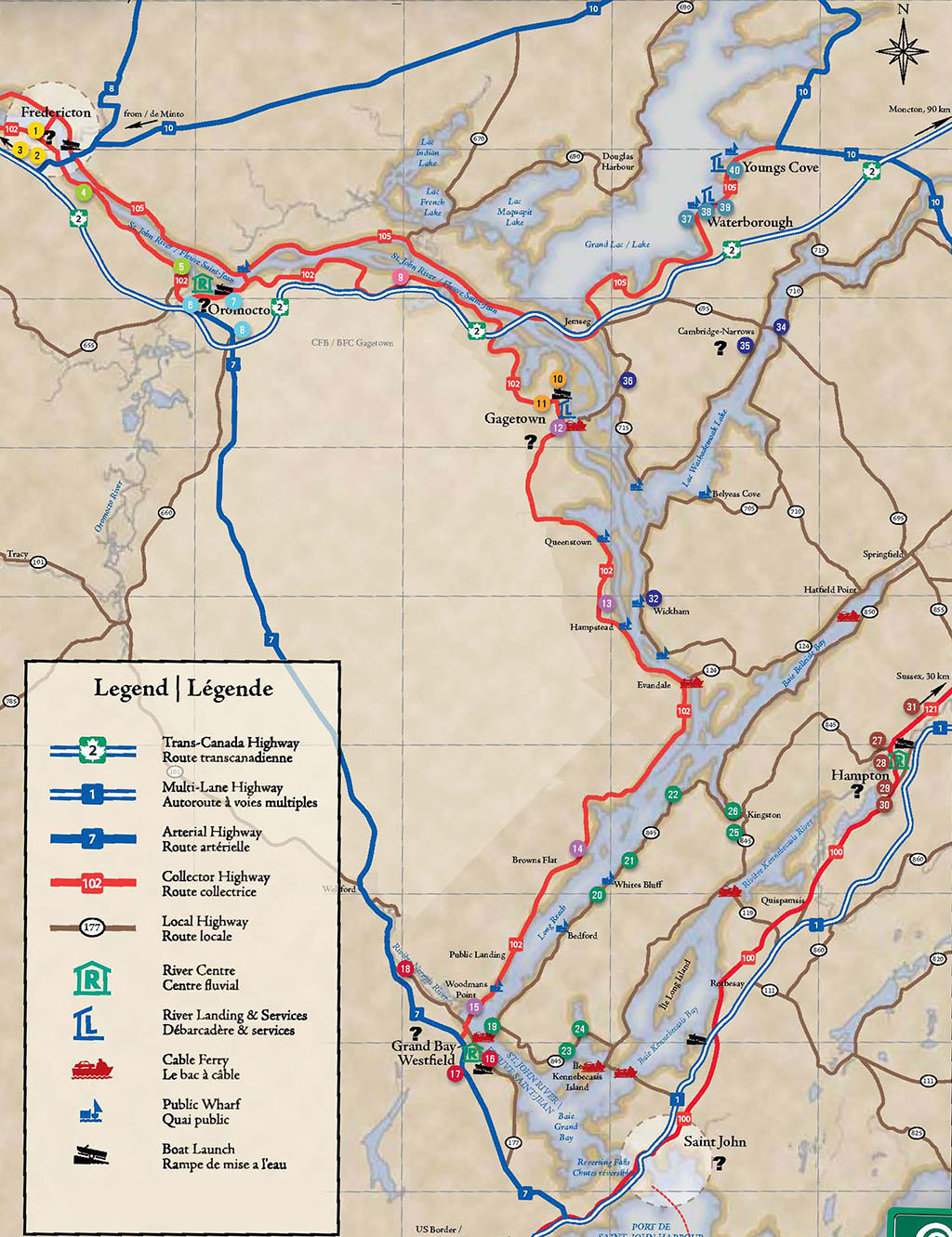
1. Christ Church Cathedral (1853) | Cathédrale Christ Church (1853)

2. Historic Garrison District | Quartier historique de la garnison,

3. Kings Landing Historical Settlement | Village historique de Kings Landing

4. Trans Canada Trail | Sentier Transcanadien

5. Wilmot Bluff Park | Parc Wilmot Bluff

6. Artisans in Sitting @ the Oromocto Visitor Information Centre | Centre d’artisanats au centre d’information aux visiteurs à Oromocto

7. Eco-Logical Adventures, Sir Douglas Hazen Park | Eco-Logical Adventures, Parc Sir Douglas Hazen

8. CFB Gagetown Military Museum | Musée militaire de la BFC Gagetown,

9. Babbits Meadows | Prés Babbits

10. Gagetown Rotary Park Landing | Débarcadère du parc Gagetown Rotary

11. Gagetown Marina | Marina de Gagetown

12. Gagetown lighthouse | Phare de Gagetown

13. The George Slipp Legacy Marsh | Le marais George Slipp

37. Fanjoys Point Cemetery | Cimetière Fanjoys Point
38. Waterborough Wharf | Quai Waterborough
39. Waterborough Baptist Church (1888) | Église baptiste Waterborough
40. Youngs Cove Wharf | Quai Youngs Cove

34. Cambridge-Narrows Conservation Park | Parc Pines Conservation

35. Anthony Flowers House

36. Saint James Stone Church | Église en pierre Saint James

32. Wickham Wharf | Quai Wickham

31. The Barn in Bloomfield

27. Kredl’s Corner Market
28. Lighthouse Park River Centre | Centre fluvial Lighthouse Park
29. Spooner Island Rotary Nature Park | Parc Rotary de Spooner Island
30. St. Paul’s | Église St. Paul’s (1871)

14. Kiwanis Picnic Site (Caton’s Island) | Aire de pique-nique Kiwanis (île Caton)

22. The Pottery Shop

25. Carter House Tea Room
26. Trinity Church | Église Trinity

20. Whites Bluff Wharf | Quai Whites Bluff

21. St. James Church | Église St. James

18. Mount Hope Farm Provincial Historic Site | Lieu historique provincial de la ferme de Mount Hope

15. Nerepis River Marsh and Picnic Site | Le marais de la rivière Nerepis et aire de pique-nique

16. Brundage Point River | Centre fluvial Brundage Point

17. Westfield United Church | Église unie Westfield

19. Hardings Point

23. Bayswater lighthouse | Phare de Bayswater

24. Milkish Inlet Covered Bridge | Pont couvert Milkish Inlet

Fredericton

Fredericton has all the amenities of a capital city, and then some: a downtown cathedral copied from a 13th century English church, a  Second Empire-style legislature, a beautiful riverside for strolling, a large park with centuries-old trees and one of the province’s best  Saturday farmers markets. And, of course, restaurants, pubs and shops. For a side trip, take the old highway (Route 102) west along the St. John River to Kings Landing, a replica 19th century village. On your way back, cross the Mactaquac Dam, turn right onto Route 105 and return to Fredericton on the north side of the river.

Oromocto

Oromocto is New Brunswick’s military town, tracing its heritage back to 18th century fortifications and owing its modern form to CFB Gagetown — the largest military base in the Commonwealth. The town is also a good launching point for  exploring the river. Sir Douglas Hazen Park offers canoes and kayaks for rent and features a Saturday farmers market.

Gagetown

The Village of Gagetown is a mecca for artists, birders and boaters. Start at RotaryPark Landing to learn some area history. Tour artists’ studios — Gagetown is noted for its distinctive pottery and  weaving. Enjoy a meal and visit shops housed in heritage buildings on Front Street. Some of the province’s best birding is also found here, including species rarely seen elsewhere.

1.  Christ Church Cathedral (1853), Corner of Church & Brunswick St.
2.  Historic Garrison District, Corner of Regent & King St.
3.  Kings Landing Historical Settlement, Exit #253 Trans-Canada Highway (or Rte. 102)

6. Artisans in Sitting @ the Oromocto Visitor Information Centre, Intersection of Waasis & Restigouche Rd.

7.  Eco-Logical Adventures, Sir Douglas Hazen Park, Onondaga St.

8. CFB Gagetown Military Museum, Building A-5, CFB Gagetown

10. Gagetown Rotary Park Landing, north end of Front St.

11.  Gagetown Marina, 50 Front St.

Fredericton to Oromocto (18 km)

Take Route 102 downriver. The Trans Canada Trail runs parallel to the road and is ideal for a leg stretch. Just past the city limits, a picnic site overlooks the river. This low-lying road passes leisurely through small communities that have grown together over the years, and it offers breathtaking river views. Lincoln  Road/Route 102 South. Access to Trans-Canada Highway.

Oromocto to Gagetown (38 km)

This is a  beautiful ride through gently rolling countryside. The river here is wide and island-studded, changing its appearance with the seasons, as the islands and intervales flood in the spring, only to emerge as bright green marshes and summer pasture for cattle, before fading to waves of yellow grass in fall. Pass Pine Grove, where mature eastern white pines line both sides of the road. Walk at Babbits Meadows and glimpse eagles and osprey hunting from the silver maples by the river. Route 102 South.

Gagetown to Grand Bay-Westfield (68 km)

This scenic winding road offers excellent stopping and picnic sites, including one overlooking historic Caton’s Island and one at the Nerepis River Marsh. This site and the George Slipp Legacy Marsh are exceptional for birding, especially waterfowl. Route 102 South.

4. Trans Canada Trail
(off Lincoln Rd.)

5. Wilmot Bluff Park
    Thatch Rd. (off Rte. 102), Lincoln

9. Babbits Meadows
525 Route 102

12. Gagetown lighthouse
Jemseg Ferry Rd. (off Rte. 102 )

13. The George Slipp Legacy Marsh
       Rte. 102, Hampstead

14. Kiwanis Picnic Site (Caton’s Island)
Rte. 102, Browns Flat

15. Nerepis River Marsh and Picnic Site
       Rte. 102 (above intersection with Rte. 177)

Grand Bay-Westfield

Begin your visit of the charming town of Grand Bay-Westfield at the Brundage Point River Centre. It offers information on the heritage of this area, a guide to some of the best river views, and directions to walking trails, boat launches and a swimming beach. A summer cottage refuge for Saint Johners in the steamboat era, Grand Bay-Westfield has a rich Loyalist history, with such fascinating sites as Mount Hope Farm. Many of the houses  in Westfield were reconstructedin the 1920s after a catastrophic forest fire. Access to Route 1: St. Stephen/Calais, Maine (west) and Sussex/Moncton (east).

16. Brundage Point River Centre, 4 Ferry Rd. (off Rte. 177)

17. Westfield United Church  (1922), 133 Nerepis Rd./Rte. 177

18. Mount Hope Farm Provincial Historic Site, 690 Nerepis Rd./Rte. 177

Grand Bay-Westfield to Hampton

via the Kingston Peninsula (63 km)

Grand Bay-Westfield to Hampton via the Kingston Peninsula (63 km) Cross on the free Westfield cable ferry to the historic Kingston Peninsula. The route divides to take you either along the north or the south  shore of the peninsula, both with gorgeous views  of the water. These two roads wind through hills and valleys for an exhilarating ride. Pass wharves, lighthouses, a covered  bridge and historic churches. Visit cemeteries where gravestones  date back to the 18th century. Settled in 1783, the Kingston Peninsula is one of the earliest areas of Loyalist settlement in  New Brunswick. Finally, stop in Kingston for a meal, some
shopping and the museum. This lovely village features two Saturday farmers markets and Trinity Church, a National Historic Site. Westfield Ferry to Route 845. Either west on Route 845 (32 km) or east (42 km) to Kingston. From Kingston, Route 845 East, then Route 121 West, to Hampton (21 km).

Via Saint John (60 km)

This alternative loop takes you into Saint John, where you can visit Reversing Falls and stop at the Saint John City Market — the oldest operating city market in Canada. Saint John offers arts, culture, dining and entertainment. The New Brunswick Museum is here, and the city’s Victorian architecture is unmatched in New Brunswick. Route 177 South and Westfield Road to Saint John (22 km). From Saint John, Route 100 East to Hampton (38 km).

19. Hardings Point (Historic Home), Westfield Ferry crossingRoute 845 West:

20. Whites Bluff Wharf, Whites Bluff Wharf Rd., Long Reach

21. St. James Church (1843), 3365 Rte. 845, Long Reach

22. The Pottery Shop, 1 Shampers Bluff Rd., Shampers Bluff Route 845 East:

23. Bayswater lighthouse, Bayswater 24. Milkish Inlet Covered Bridge, Bayswater Kingston:

25. Carter House Tea Room, 874 Rte. 845

26. Trinity Church (1789), 3949 Rte. 845

Hampton

Whichever route you choose, Hampton is worth the visit. The Lighthouse Park River Centre offers canoe and kayak rentals, as well as boat tours. The nearby Hampton Marsh is one of the most fertile and productive wetlands in the province, with spectacular birding on well-worn park trails. This vibrant community also features heritage sites, artists’ studios and shops.


27. Kredl’s Corner Market, 34 Pickwauket Rd.
28. Lighthouse Park River Centre, 1075 Main St.
29. Spooner Island Rotary Nature Park, Rte. 121
30. St. Paul’s (1871), 486 Kennebecasis River Rd.
31. The Barn in Bloomfield, 569 Rte. 121, Bloomfield

Hampton to Fredericton via Cambridge-Narrows (166 km)

There are several scenic routes heading back to Fredericton, featuring low-traffic secondary highways. The communities along the way have public wharves or riverside parks. Jemseg boasts a Saturday farmers market and worldclass birding. Route 121 East (10 km) to Route 855 North (9 km). Then Route 124 West (21 km) to Route 705 West. Right onto Route 705 (32 km) to Route 710 North and then left on 710 (14 km). From Cambridge-Narrows, Route 695 North to Route 715 West (31 km). From Jemseg, Route 105 North (49 km) to Fredericton.

32. Wickham Wharf, Wickham Wharf Rd., (off Rte. 705)
34. Cambridge-Narrows Conservation Park, 1307 Bridge Rd./Rte. 695, Cambridge-Narrows
35. Anthony Flowers House, 2270 Lower Cambridge Rd./Rte. 715 Cambridge-Narrows
36. Saint James Stone Church (1887), 647 Rte. 715, Lower Jemseg

Via Jemseg (105 km)

Route 121 East (10 km) to Route 855 North (9 km), across the Kingston Peninsula to Route 124 West (3 km). Then Route 695 North to Jemseg (34 km). Route 105 North (49 km) along the river to Fredericton.

Add a Ferry Hop ( 131 km)

Why not add a free ferry to your ride? It’s possible to bypass Cambridge-Narrows and Jemseg, returning to Route 102 by the Evandale cable ferry. Follow Route 124 West to its end at the Evandale Ferry landing

Add Grand Lake (35 Km)

This route skirts east along the southern shore of Grand Lake, the largest inland body of water in the Maritimes. Churches and cemeteries provide a glimpse into the past. Stop by vegetable stands for local produce and treats, and picnic along the way. Spectacular vistas, boating, swimming and beaches add up to a grand day on Grand Lake. Route 105 South to Route 10 East. Access to the Trans-Canada Highway.


37. Fanjoys Point Cemetery, Rte. 105, Fanjoys Point
38. Waterborough Wharf, Rte. 105, Waterborough
39. Waterborough Baptist Church (1888) 12 Union Settlement Rd., Waterborough
40. Youngs Cove Wharf, Rte. 105, Youngs Cove