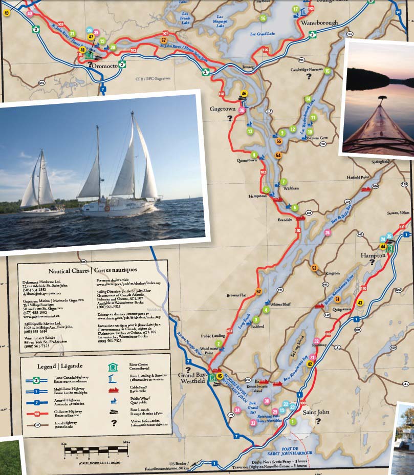
Getting On & Around the Water in the Lower River Passage of the St. John River
About the Boating Route
The Lower River Passage offers some of the finest inland water experiences on the eastern seaboard. Whether your passion is sailing, powerboating, canoeing or kayaking, satisfy it here. The Passage blends solace and serenity, long open reaches and placid secret coves, dominating cliffs and hidden wetlands. Each bend in the river reveals another vista, yet another scene of remarkable beauty. Throughout the region, wharves and boat launches are open to the public. Landings and river centres offer information and washrooms; marinas provide gas and pump-out service; and cruising guides, along with local boaters, share advice.
The Lower River Passage is a Trans Canada Trail Water Route, the first designation of its kind in Atlantic Canada. It features two trailheads — Sir Douglas Hazen Park in Oromocto and the Brundage Point River Centre in Grand Bay-Westfield — as well as 10 other TCT access points, making for an inviting and accessible water trail.


39. Oromocto Boat Club Sir Douglas Hazen Park
47. Hazen Park Centre/ Sir Douglas Hazen Park TCT Water Route Trailhead
19. Burton Courthouse Wharf
44. Lighthouse Park River Centre
42. Renforth Rotary Park
22. Go Fundy Events
23. Gibson Creek Canoeing
29. Saint John Power Boat Club
Saint John
Settled by Loyalists in the 1780s, Saint John has a rich history to share.
ere the Bay of Fundy meets the St. John River at the worldfamous Reversing Falls Rapids, and the port city looks with pride over both these bodies of water. Boaters entering from the bay will find all the information they need to navigate the falls safely and will be well rewarded for their decision to explore the beautiful Lower River Passage.
Visitors can also enjoy day adventures on the water.
1. Small Craft Marine Facility at Market Slip
45° 16’ 21” N 066° 3’ 57” W
Market Sq., Saint John
Dock (holding area for slack tide at Reversing Falls)
22. Go Fundy Events
(506) 672-0770
www.gofundyevents.com
Kayak sales & adventures –24 hr. advance booking required
23. Gibson Creek Canoeing
821 Anderson Dr., Saint John,
(506) 672-8964
Canoe & kayak tours, custom vacations – 24 hr. advance booking required
29. Saint John Power Boat Club
45° 16’ 40” N 066° 05’ 2” W
100 Kennedy St., Saint John
(506) 642-5233
Boat launch, transient slip, fuel, diesel
Kennebecasis Bay & River
Derived from the Mi’kmaq for “little long bay place,” the Kennebecasis is an arm of the St. John River in its lower stretch with a rich yachting tradition, due to its deep water, fine breezes and beautiful scenery.
The shallow upper Kennebecasis offers opportunities for small boat, canoe and kayak exploration of the river, tributaries and wetlands. Although runs are reduced from historical levels, the Kennebecasis remains an Atlantic salmon bearing stream, thanks to continuing conservation and restoration activities.
30. Royal Kennebeccasis Yacht Club
45° 18’ 15” N 066° 6’ 13” W
1042 Millidge Ave., Saint John
(506) 632-0186
www.rkyc.nb.ca
Boat launch, public moorings, transient slip, fuel, diesel, pump-out
31. Renforth Boat Club
45° 21’ 29” N 066° 0’ 52” W
32. Rothesay Yacht Club
45° 23’ 35” N 066° 0’ 1” W
8 Wharf Rd., Rothesay
(506) 847-7245
www.rothesayyachtclub.com
Boat launch, public moorings, transient slip, pump-out
42. Renforth Rotary Park
45° 21’ 28” N 066° 0’ 53” W
Wharf St., Renforth
Boat, canoe & kayak launch, wharf
43. Hammond River Angling Association
45° 27’ 60” N 065° 54’ 21” W
10 Porter Rd., Nauwigewauk
(506) 832-1230
www.hraa.ca
Small boat, canoe & kayak launch
25. Osprey Adventures
45° 32’ 29” N 065° 50’ 10” W
1075 Main St., Hampton
(506) 832-6025
www.ospreyadventures.net
Canoe & kayak rentals, guided tours
44. Lighthouse Park River Centre
45° 32’ 29” N 065° 50’ 10” W
1075 Main St., Hampton
(506) 832-6096
www.townofhampton.ca
Boat launch, dock, interpreti ve
centre, washrooms
51. Forresters Cove Anchorage
45° 27’ 28” N 065° 56’ 25” W
Grand Bay to Evandale
This is the section of the waterway that gave rise to the St. John River’s early nickname, “Rhine of North America.”
It includes Grand Bay, where the waters of the St. John and Kennebecasis rivers come together to flow out through the Reversing Falls.
Prominent features are the sandbars of Brandy Point and Oak Point and the confluence of the Nerepis at the base of the Long Reach, leading to the hidden beauty of Belleisle Bay.
Here are the open stretches of river (“reaches” to sailors), filled with sparkling light and uninterrupted views of horizons bounded by wooded hills.
In Belleisle Bay, secluded coves are tucked into the shoreline like pirates’ treasures.
2. Public Landing Wharf
45° 24’ 25” N 066° 11’ 43” W
Rte. 102, Public Landing
33. Saint John Marina/MV
Voyageur II
45° 16’ 47” N 066° 9’ 18” W
2050 Westf ield Rd., Saint John
(506) 738-8484
www.saintjohnmarina.com
Boat launch, transient slip, fuel,
diesel, pump-out. Boat tours –
24 hr. advance booking required
34. Marti non Yacht Club
45° 17’ 46” N 066° 10’ 51” W
45. Brundage Point River Centre
TCT Water Route Trailhead
45° 20’ 53” N 066° 13’ 26” W
4 Ferry Rd., Grand Bay-Westf ield
(506) 738-6406
www.town.grandbay-westfield.nb.ca
Boat launch, dock, public moorings,
interpreti ve centre, washrooms
3. Bedford Wharf
45° 25’ 37” N 066° 8’ 58” W
Bedford Wharf Rd. (off Rte. 845)
Bedford
4. Whites Bluff Wharf
45° 27’ 38” N 066° 6’ 25” W
Whites Bluff Wharf Rd. (off Rte. 845)
Long Reach
35. Belleisle Bay Marina
45° 33’ 33” N 065° 58’ 24” W
391 Rte. 850, Erbs Cove
(506) 832-7373
Boat launch, public moorings, pump-out
52. Whelpley Cove Anchorage
45° 28’ 47” N 066° 7’ 15” W
53. Kingston Creek Anchorage
45° 32’ 27” N 065° 59’ 54” W
Evandale to Gagetown
(including Washademoak Lake)
The stretch from Evandale to the Jemseg River is a spectacular river run.
The ghosts of the great steamboats whistle here still, faintly echoing around the public access wharves that were their ports of call.
In summer, the seasonally flooded islands serve as rich pastures for cattle. Washademoak Lake remains the traditional boating and summering place that it has been for generations along the river.
5. Gerows Wharf
45° 36’ 32” N 066° 3’ 16” W
Rte. 705, Beulah
6. Hampstead Wharf
45° 37’ 31” N 066° 05’ 2” W
Hampstead Ferry Rd. (off Rte. 102)
Hampstead
7. Wickham Wharf
45° 38’ 40” N 066° 4’ 31” W
Wickham Wharf Rd. (off Rte. 705)
Wickham
8. Queenstown Wharf
45° 41’ 20” N 066° 06’ 30” W
Queenstown Wharf Rd. (off Rte. 102)
Queenstown
54 Hole-In-The-Wall Anchorage
45° 41’ 17” N 066° 4’ 52” W
9. Colwells Wharf
45° 43’ 21” N 066° 4’ 37” W
Colwells Wharf Rd. (off Rte. 715)
Lower Cambridge
55 Colwells Creek Anchorage
45° 42’ 47” N 066° 5’ 35” W
10. Websters Wharf
45° 42’ 59” N 066° 0’ 57” W
Belyeas Cove Rd. (off Rte. 705)
Belyeas Cove
11. MacDonalds Point Wharf
MacDonalds Point Wharf Road
45° 43’ 05” N 066° 02’ 51” W
12. Mott s Wharf
45° 44’ 28” N 066° 01’ 18” W
Mott s Wharf Rd. (off Rte. 715)
Central Cambridge
13. Fox Wharf
45° 44’ 30” N 066° 07’ 59” W
off Rte. 102, Hampstead
14. Humphreys Wharf
45° 47’ 1” N 065° 59’ 13” W
Humphreys Wharf Rd. (off Rte. 715)
MacDonald Corner
15. Cambridge-Narrows Wharf
45° 49’ 46” 065° 57’ 12” W
Cambridge-Narrows Wharf Rd.
(off Rte. 695) Cambridge-Narrows
36. Gagetown Marina
45° 46’ 58” N 066° 8’ 33” W50 Front St., Gagetown
(506) 261-2309
www.gagetownmarina.ca
Public moorings, transient slip, fuel, diesel, pump-out, canoe & kayak rentals
46. Gagetown Rotary Park Landing
45° 47’ 18” N 066° 8’ 38” W
Front St., Gagetown
(506) 488-3567
Boat, canoe & kayak launch & washrooms
Grand Lake
Spend a grand day on Grand Lake!
The narrow channel of the Jemseg River bursts open into the largest freshwater lake in the Maritime Provinces.
Destinations and communities around the entire perimeter of the lake are an invitation to slow down, and spend some time with the people and stories of this area.
For canoeists and naturalists, the spectacular wetlands of the Grand Lake Meadows are a particular treat.
16. Douglas Harbour Wharf
45° 55’ 8” N 066° 5’ 55” W
Rte. 690, Douglas Harbour
Canoe & kayak launch
17. Waterborough Landing
45° 54’ 28” N 066° 00’ 56” W
Rte. 105, Waterborough
Canoe & kayak launch, wharf, public moorings, picnic site
18. Youngs Cove Landing
45° 56’ 45” N 065° 58’ 25” W
Rte. 105, Youngs Cove
Canoe & kayak launch, wharf, public moorings, picnic site
56. Flowers Cove Anchorage
46° 2’ 1” N 066° 2’ 5” W
37. Newcastle Creek Marina
46° 2’ 31” N 066° 1’ 6” W
4028 Rte. 690
Newcastle Creek Boat launch, public moorings, pump-out
38. Chipman Marina
46° 10’ 35” N
065° 52’ 58” W
Main St., Chipman
(506) 339-6601
www.chipmannb.com
Boat launch, public moorings, transient slip, pump-out
Gagetown to Fredericton
This area is steeped in history.
In its backwaters, listen to the dip of the paddle of the birch bark canoe that dominated travel here for over 10,000 years.
Weave between the islands and drift beside centuries-old seasonal pastures where cattle have grazed for over 300 years.
Thee Loyalist village of Gagetown is now one of the province’s artisan centres. The town of Oromocto’s full marina and riverside park are an easy walk to restaurants and shopping.
Further upstream, the capital city of Fredericton offers museums, shopping and fine dining.
19. Burton Courthouse Wharf
45° 51’ 52” N 066° 26’ 59” W
River Road Burton
20. Maugerville Wharf
45° 52’ 8” N 066° 26’ 57” W
Rte. 105, Maugerville
26. Eco-Logical Adventures at the Small Craft Aquatic Centre
Sir Douglas Hazen Park
45° 51’ 18” N 066° 28’ 25” W
Onondaga St., Oromocto
(506) 357-6868
www.ecologicaladventures.ca
Canoe, kayak & bike rentals
39. Oromocto Boat Club
Sir Douglas Hazen Park
45° 51’ 13” N 066° 28’ 36” W
Onondaga St., Oromocto
(506) 357-7374
www.oromoctoboatclub.ca
Boat launch, transient slip, fuel, pump-out
47. Hazen Park Centre/
Sir Douglas Hazen Park
TCT Water Route Trailhead
45° 51’ 18” N 066° 28’ 25” W
Onondaga St., Oromocto
(506) 357-4459
www.oromocto.ca
Boat, canoe & kayak launch,
interpreti ve centre, washrooms
48. Wilmot Bluff Launch
45° 52’ 07” N 066° 30’ 25” W
Thatch Rd. (off Rte. 102)
Lincoln
Boat, canoe & kayak launch
57. Ram Island Anchorage
45° 51’ 62” N 066° 15’ 35” W
21. Upper Maugerville Wharf
45° 53’ 29” N 066° 31’ 56” W
Rte. 105, Maugerville
27. Small Craft Aquatic Centre
45° 57’ 59” N 066 37’ 7” W
63 Brunswick St., Fredericton
(506) 460-2260
www.smallcraft .ca
Canoe & kayak rentals, lessons
28. St. John River Boat Tours
Fredericton
(506) 458-0689
Boat tours of the St. John,
Oromocto & Kennebecasis
rivers – 24 hr. advance booking
required
40. Fredericton Yacht Club
45° 55’ 56” N 066° 37’ 22” W
Lincoln Rd., Fredericton
www.fyc.ca
Boat launch, public moorings
41. Regent Street Wharf
45° 57’ 43” N 066 38’ 13” W
516 Queen St., Fredericton
www.fredericton.ca
Dock, public moorings
49. Morrell Park Launch
45° 56’ 53” N 066° 37’ 55” W
Waterloo Row, Fredericton
www.fredericton.ca
Canoe & kayak launch
50. Carleton Park
Boat Launch
45° 57’ 41” N 066° 37’ 36” W
Intersection of Gibson & Union Streets, Fredericton
www.fredericton.ca
Boat, canoe & kayak launch